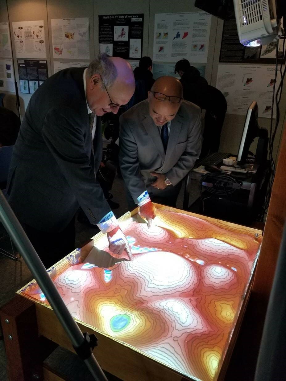
President Fritz and VP Iwama experiment with the Augmented Reality sandbox.
In its 13th consecutive year, the College of Staten Island participated in International Geography Awareness Week in conjunction with people all around the globe, by hosting a GIS (Geographic Information Systems) Day Conference on November 14, 2018. This year was particularly noteworthy as event organizer, Urban Policy Analyst and GIS Specialist at CSI Nora Santiago brought to life New York City’s only Augmented Reality Sandbox. Utilizing powerful 3D visualization applications and simulation software, originally created by researchers at UC Davis, the AR sandbox serves as a hands-on exhibit allowing users to create topography models by shaping real sand. The system teaches geographic, geologic, and hydrologic concepts such as how to read a topography map, the meaning of contour lines, watersheds, catchment areas, levees, etc. The Nicotra Group awarded CSI with a $500 grant to sponsor Lifestyles for the Disabled to construct the sandbox.
GIS is a framework for gathering, managing, and analyzing data. Rooted in the science of geography, GIS integrates many types of data. It analyzes spatial location and organizes layers of information into visualizations using maps and 3D scenes. With this unique capability, GIS reveals deeper insights into data, such as patterns, relationships, and situations, helping users make smarter decisions. GIS is a critical back-end component to many businesses, Ms. Santiago notes, “Geographic Information Systems is a tool that many of us use but we are not aware of it. Your app or Website is relying on GIS technology when you are looking for the nearest place to eat or shop. GIS is a backbone of many online services and games today. GIS allows for processing spatial data quickly and accurately, making it an essential tool for companies and government agencies.”
Funded and sponsored by CSI, the CSI Technology Incubator, the Office of Workforce Development and Innovation, and the Division of Economic Development, Continuing Studies, and Government Relations, CSI’s GIS Day celebration gathered distinguished faculty in the fields of geology, finance, and geography; public and private civic engagement organizations; and college and high school students. Following remarks on the importance of GIS in our everyday lives by CSI President William J. Fritz and Vice President for Economic Development, Continuing Studies, and Government Relations Kenichi Iwama, Professors Dr. Alan Benimoff, Dr. Nerve Macaspac, and Dr. Jonathan Peters explored the critical components of GIS technology and its valuable uses. Dr. Macaspac stated, “GIS, is a tool that integrates a variety of social and spatial information. It is through this integration that GIS serves as a powerful tool to better understand geographic phenomena and place-specific processes, both historical and contemporary. I look forward to working with CSI students in discovering the world of GIS and exploring the power of digital mapping and critical cartography in re-imagining the world we live in and proposing creative solutions to many important social and environmental issues we face.”
NYC Public Library Geospatial Librarian and Map Curator Ian Fowler highlighted the changing dynamics of public libraries as the evolving accessible public data sets are more frequently becoming digitized. Emily Goldman, the Director of Civic Innovation Fellowship Program at BetaNYC, expounded on how their civic organization aims at improving lives in New York through civic design, technology, and data information. BetaNYC helps local communities build a civically engaged technology ecosystem by simplifying data for anyone to use, create, and participate in the decision making process.
In partnership with the 30,000 Degrees Initiative, which strives to increase the number of college graduates with a bachelor’s degree or higher from Staten Island by 30,000 to prepare the future entrepreneurs, professionals, engaged citizens, and leaders that the borough needs as it rises to meet the challenges and opportunities of tomorrow, New Dorp High School was invited to join CSI’s GIS Day celebration.
Assistant Principal of CTE/Technology at New Dorp High School, Salvador Contes, Jr., remarks, “Our New Dorp High School students participated in the annual GIS Day at CSI. Students were invited to participate in GIS talks provided by various presenters throughout CSI. At the conclusion of the talks, our students were thrilled and gravitated to the GIS sandbox. They were able to see the connections from their Earth Science class and the relevance of the material they are learning. Our teachers also were excited to ‘play with the sandbox’ as well. They even came back and mentioned to me that they also didn’t want to leave CSI because they wanted to learn more about the coolest sandbox they have ever played with!”
For more information, visit www.gisday.com.